Canary Islands…
 October / November 2019
After an amazing adventure in Morocco we set off for the Canary Islands. 460 or so miles to Graciosa, the first of the inhabited Canary Islands and a national park.

The Rabat (Morocco) harbor had been closed several days prior due to a large swell at the entrance so when the opportunity came, we went.
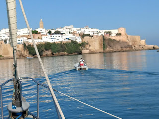 Boats were permitted to leave, however the remnants of Hurricane Dorian were still being felt down the African coast.
We followed the marina tender boat down the river to sea, leading the 8 other departing cruisers. Clearing the jetties and break wall we felt the 5+ foot swell immediately. There was not enough wind to sail but we had a helping 1- 2 knot current which gave us a nice push south.
By noon, the wind was up enough to sail so up went the canvas which diminished the rocking motion from the swell. We continued through the night, sailing along but by 5:30am the next morning we were forced to drop sail and motor…

The Rabat (Morocco) harbor had been closed several days prior due to a large swell at the entrance so when the opportunity came, we went.
 Boats were permitted to leave, however the remnants of Hurricane Dorian were still being felt down the African coast.
 We followed the marina tender boat down the river to sea, leading the 8 other departing cruisers. Clearing the jetties and break wall we felt the 5+ foot swell immediately. There was not enough wind to sail but we had a helping 1- 2 knot current which gave us a nice push south.
By noon, the wind was up enough to sail so up went the canvas which diminished the rocking motion from the swell. We continued through the night, sailing along but by 5:30am the next morning we were forced to drop sail and motor…

 The winds came back by noon and we set the sails for downwind sailing, wing and wing doing a respectable 6-7 knots with a favorable current.
A song bird hitch a short ride, then a large pod of Atlantic bottle nose surfaced (8-10 foot long) and kept us entertained for half an hour.
 The only chore was to tweak the auto pilot as the current caused some leeway drift. Our lunch was interrupted by another visitor. An owl!
 It circled several times very close hoping for a perch before attempting the masthead. We were happy to provide a rest for the weary drifter but our instruments were in great damager from his size and weight, should he take hold. Unfortunately / fortunately, it was not able to get a grip and flew off… Jim checked the GPS for our coordinates; the nearest land was over 80 miles off, Africa. Our guess is it was blown south from Europe with the winds from Dorian and got disoriented… we don’t think this owl was native to Africa.

Day 3 and still sailing and tweaking coarse. The fleet we left Rabat with has long gone over the forward horizon having opted for their motors in the light winds. But, we were still moving steadily and on coarse so we continued along at a sails pace.
More dolphins. Another song bird. A wave in the cockpit, nice and salty seating (grrr).

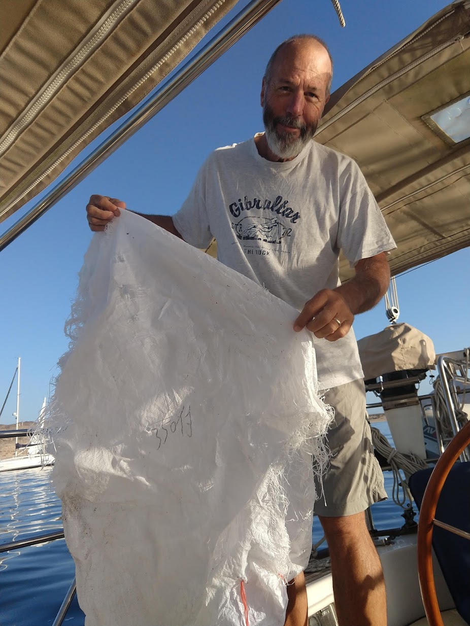
After 3 days and a few hours, the island of Graciosa and Lanzarote could be seen clearly on the horizon, their volcanic peaks spouting up from the depths. We decided it was time to drop the sails and motor the last 8 miles to the anchorage, allowing us to arrive just before the sunset. The headsail was rolled up, the pole stowed (the pole keeps the sail in position opposite the main sail for downwind sailing). Kathy went below to fetch gear, Jim started the engine… grunk… ?? that didn’t sound right … Jim carefully eased the shifted into gear … screech! Kathy popped the floorboard up to see water gushing in… NOT good! Jim shifted back into neutral, the water halted and the prop shaft returned to its proper position… Suspected Diagnosis: something has fouled the prop. A fishing line most likely having passed countless dozens along the route.
 Options: dive under the boat to see what the problem is. Nope. Open see with no propulsion and a heavy boat. Recipe for disaster.
Call the authorities and request boat for a tow. Huge costs can be incurred and the tow / salvage boat is 20 miles away. not off the table…
Sail back out to sea and wait
Sail on the the next port city and request a tow there… That means arriving after dark, a tow boat and unknown conditions…
or, sail into the intended anchorage and lie at anchor for the night and assess the situation in the daylight.
After a crew meeting, we decide sailing to the nearby anchorage was the best and safest option. If all went well, we could arrive just at sunset.
So, the sails went back up and the wind died down, of course. Our hearts pounding our minds racing, reviewing the upcoming maneuver. We had practiced ‘anchoring under sail’ years ago with our mentor and friend, Larry Mims. ThankYou!
Graciosa
 We made the Anchorage just after sunset with just enough light to see the aluminum forest of masts already settled in for the night. We made a slow and deliberate circle of the harbor, selected a spot and retreated for a second entry. The sun was well on her way to tomorrow, so we used flashlights and most of the deck lights we had as we ghosted in and dropped the anchor in 50 feet of water and little wind; not enough to set the hook. But, also not enough wind to drag us out to sea!
After a calm night we were up and ready to tackle the problem. Jim took the plunge. Based on the shrill chirp from Jim as he resurfaced, Kathy concluded it was rather chilly. Jim caught his breath as he acclimated to the sea temps then dove in earnest to inspect the prop. He popped up for another breath then dove again, this time bringing up a huge reinforced piece of industrial bag, which he plucked off the prop like a cherry. Jim surveyed the prop again then the hull before returning to the deck. A test of the engine and inspection of the prop-shaft and seal confirmed the problem was solved!
We stayed on at the Graciosa anchorage another day before setting off of the island of Lanzarote and the marina. An uneventful motor. We were directed to a berth and welcomed ashore. For Kathy, an ocean passage can be simultaneously stimulating and boring… Jim always seems in his element…
Lanzarote
 We requested a months berth at Marina Lanzarote, Arrecife. Kathy would need to return to the US and northern Michigan to see and assist if possible with her mother (95) who had fallen just days before and cracked her vertebrae and undergone emergency surgery. So, tickets were purchased and arrangements made to return ‘home’.

There are no trees except those which have been imported and planted by residents.

Humans have been trying to inhabiting the islands since their discovery, little by little changing the landscape. The numerous lava fields alternately blanketed in smooth solidified molten lava and the sharp jagged ‘a-a’ volcanic fields. The ‘a-a’ name sort of describes the sound that one would make if walking across the area… akin to stepping on mounds of jacks abandoned by children… a bloody, painful trail filled with expletives.
 Lanzarote is loosely populated , pockets of settlements easily spotted, their characteristic white washed homes nestled together against the brown black backdrop of stark stone and pumice. The entire island housing communities are painted in white with few exceptions. The window trim and door color choices; black or forest green.
We covered a lot of the island over the next few days. Leisurely driving the coast and interior. Stopping at tourist attractions and exploring the landscape.

 Mirador del Rio : an overlook between Lanzarote and Graciosa. Graciosa has 2 very small villages and no paved roads. The only access is by boat. Volcanic… Very secluded and laid back.

Cueva de los Verdes : Lanzarote has 2 caves open to the public. They are actually old Lava tubes. As the volcanos were erupting and the island was forming, lava spewed in many forms, sometimes making under ground rivers or conduits of hot molten lava. A lava tube forms when the molten lava ceases to flow but the rock around it solidifies and creates a tube. A ‘cave’ is then formed. The interior offers a glimpse below the surface, many forms of lava rock can be seen. This cave had ‘hidden’ lake within, it’s surface water reflecting the rocks above appeared to be a continuation of the cave leading down to the unknown. It’s not until a rock is tossed in the water that the ‘magic’ is released to reveal the lake.


Ville de Teguise : Sunday market. A huge market held every Sunday draws thousands of tourists and locals. Most of the village is transformed with popup tents selling lots of gobbledygook…toys, leather goods, purses and blankets. Shirts and skirts. Shoes and belts.


There are plenty of ways to fill your belly too. Beverages of coffee, tea, beers and sangria. Snacks of all sorts; sweet rolls, cakes and hot sandwiches.
Children's boats made of old oil drums ...

Mountanas del Fuego / Timanfaya : a fantastic landscape stretching for miles and miles. The last eruption on Lanzatorte was around 300 years ago. At that time there were a few sparse villages, several of which were buried under the lava flow. The area now is a national park with roads traversing the barren fields and stark landscape.


Islote de Hilario : Though the island has now seen an active eruption for 3 centuries, the volcanic activities continue below.
At the Hilario park station we watched demonstrations by park rangers. They poured small amounts of water into the heat vents, a few moments later the water vaporizes and shoots out of the vent in a column of steam.

At another demonstration a ranger uses a long pitchfork to force brush into a vent. Several minutes later, the brush catches fire due to the extreme temperatures evacuation from the vent. The restaurant also uses one of the heat vents to cook chicken, slow roasting over an exposed vent.

The main attraction at the site however, is the drive in and through the lava field. Visitors are ushered into busses and driven around the park over differing lava flows, up and around volcanic peaks and calderas and through and exposed lava tube.

Stratified City : an outcrop of layered volcanic earth, eroded by wind leaving columns and pillars of exposed charred earth and ash.


 Salt Flats / Factory : From on top of a cliff you can look down onto the sea and the salt factory. Several acres of ponds at various stages of evaporation. The finished salt mounds waiting final processing. The cliff overlooking the salt flats are perfect for the indigenous Canary Island Falcons. A petite bird living on the edge of the cliffs, hovering above then diving down to catch its prey.


 Kathy made the trip back to the US. Her mother, Helen’s fall had fractured her vertebrae, requiring surgery and hospitalization. She still lives independently and alone at 95 but this would require therapy. Kathy flew to Chicago, continuing on the following day with a quick stop in Holland, Michigan before completing the 3 day journey to Gaylord. Mom’s progress was coming along well but it was decided she would benefit from a longer stay in the rehab center, a mixed blessing. But, she will get good care and be safe and warm, winter already threatening snow and freezing temps in the coming days. It was fantastic hanging out with my big sister Terry catching up on each others lives. My other brothers and sister popped in and out as well. It was a good trip ‘home’ and put my mind at ease seeing mom and getting a few much needed hugs and kisses.
 With mom mostly sorted out, Kathy headed east to New Jersey to meet the newest member of the family… Sweet, Miss Callie who was already turning 7 months old! Callie is one of the happiest babies you will ever meet. A broad smile, big beautiful eyes and a delightful personality. Her big brother Keegan is loving and helpful… quick with hugs and ready for adventure. We had a great visit, excursions to a co-op farm for produce, apple picking and a visit to the zoo… Our few days together went much too fast. The plane back to the Canaries was uneventful.


Soon after Kathy’s return, Jim’s sister, Marianne came for a visit hoping to get some beach time in and have fun in the sun! Unfortunately, mother nature had other plans.
The Canaries experienced an extremely unusual ‘wind event’ …winds 25-30 knots sustained for over 2+ weeks… friends recorded recorded wind speeds of 49.5!

But we were not deterred… we perserved and explored more island places…

Playa Blanca : located on the south end of the island. A lovely beach town and tourist resort. Normally very picturesque. Unless there's a sand storm. The winds were fierce. Several boats in the anchorage drug while we were there, the crews struggled to reset but managed to get a hold on the bottom again.


Bajo de los Sables : A beautiful beach on the north end. Normally calm and a haven for sun seekers.


 La Santa : a surfers paradise even under normal wind conditions. The extraordinary winds made monstrous waves… Red flag warning on ALL beaches.


 Casa Museo del Campesino : tourist stop / mini village featuring local products and artisans. Marianne painted a lovely picture using ‘paint’ from crushed insect bodies that live on the prickly pear cactus.

 MIAC ; museum of art : overlook and horse sculptures. A short walk from the marina, this museum is housed in an old fort. The upper section features photos and architectural plans from Spanish artists and architects. The lower section has a cafe and restaurant that overlooks the harbor and provides closeup views of the locally famous horse sculptures. A half dozen metal fabricate horses and riders are located just off the shore. At low tide the sculptures can be seen in their entirety. As the tide rises they are swallowed by the sea then slowly emerge again as the tide falls. 2 times daily. up down up down. around 15 feet…

Camels : Near the Volcano park is a camel exhibit with optional camel ride, side saddle. Camels were once a common site on the island, their bodies able to withstand the harsh climate and lack of fresh water while providing transportation and pack service for those eking out an existence in the early years of development.


As the winds died down, so did Marianne’s time with us. We also needed to get on the move and head down island… as Marianne’s flight headed skyward, Inishnee was moving south. We anchored two nights along the coast of Fuertaventura, the next island in the Canary chain. Fewer inhabitants than Lanzarote and far more volcanoes. From sea it appeared quite desolate and foreboding. With no protected anchorages on the coast, the swell from the atlantic was noticeable… Especially at the southern point.

The breaking surf off Punta Jandia was formidable! The reef just south of the island made for breathtaking vista and heart pounding anxiety… But, our Rocna anchor held true and strong. The roll from the swell just barely tolerable, intervals of 60 - 90 seconds… you just needed to fall asleep between intervals!
 Gran Canaria
We made or way south and west the next day, using the mainsail to help slow the roll as we motored along. We were again treated to sighting of several Atlantic dolphins… Nearing the harbor, we were stowing the main when we saw a large black inner tube off the starboard side. No, big a black log??? Noooo, a whale! a pilot whale. Floating… Dead? then a breath… and it slowly slipped under the surface… wow. just wow. did we just see that? yeeees. then, behind the boat it resurfaced and again just floated along… After some thought, we believe it must have been sleeping.


Touring Gran Canaria. We were fortunate to meet up with good friends Lucia and Andrew sailing aboard Alba. Miguel, Lucia’s brother, was visiting from Portugal. We rented a car and had a day filled with exploring together. Then a couple more with the crew of Inishnee going solo.

Gran Canaria’s landscape is drastically different from Lanzarote. More mountainous and greener. Pine forests on the higher elevations, the highest summits even get snow. Las Palmas, Gran Canaria is the 7th largest city in Spain. Very modern. A thriving tourist industry from northern Europe escaping the cold and dreary winters.


Cuatro Puertas. Ancient caves carved into the top of a hill. It’s unclear the exact purpose of these caves: rituals, housing, storage, and protection for foes are all listed as possibilities.


Calderas de los Marteles . 80 meters deep, 550 meters wide. Clouds often envelope the top. Canary pine trees, sage, and highland heather surround the area. The caldera plateau has been used as farm land for many generations.


Roque Nublo… rock of the clouds. A very high peak often shrouded in cloud and mist.


Santa Lucia… we of course HAD to stop, so ‘our’ Lucia could say she was there…


Maspalomas. A large expanse Sand dunes at the south end of the island… and lovely beaches.
 GC - 200 … the scariest road on the island… and possibly the entire island chain! A 2 lane road that should be ONE way. Switch backs and hairpin turns.


 Antenara… the village at the hightest peak with an amazing restaurant ‘El Mirador de La Cilla’. Enter through a hand cut tunnel onto the spine and edge of the mountain. Sit looking over the vista of the valley below.


 Unfortunately, a devastating fire in August of this year (2019) burned thousand of acres for many miles. 9000 people were evacuated. The valley and forests are slowly making a comeback…
Agaete… a peaceful fishing village with a small tourism enclave. Also know for its coffee and banana growing industry.
 Las Palmas… busy. big. everything a consumer (or cruiser) would need or want. And home to the ARC. Atlantic Cruisers Rally. Hundreds of sail boats gather here before setting of for the Caribbean.


 We too plan to cross to the Caribbean this season but will do so from Tenerife. Our son Stephen will meet us there and crew for the passage. So, we need to haul up th he anchor and get sailing…. We left Las Palmas at 5:30 am to make the long passage, 60+ miles to Tenerife. The swell was pretty uncomfortable for the first few hours but subsided as the day wore on. Dolphins joined us. The sun shown. We made good time to Radazul where we stayed 2 nights. We cleaned and packed and stowed and organized… and, finally found space for Stephen to sleep and call home for the next few weeks…. The village was set on and up a very steep hill, which we didn’t explore. We did completely enjoy the marina, or at least the lack of any movement. Other than on the rising and falling tide the boat did not move and we slept quite peacefully.
We continued on to San Miguel on the south side of the island to meet Stephen, our newest crew member. Completely opposite setting. The tide and swell make the harbor very active. Its location to the airport and amenities make it a popular port as well. We initially had to raft off 2 other boats, but one left almost immediately so we had to shuffle around and ended up on the wall with one other boat rafting to us. Lots of lines were tied and retied. All fenders were put to use. Lots of creaking and groaning from lines. The fenders squawking as they rubbed and mashed hulls and docks.
The place was hustling with activity. Boats jostling. Crews coming and going. Locals and transients intermingling…
We spent a couple days getting us and the boat in order. Diesel for Inishnee, clean laundry for the crew. An the aft cabin / garage contents moved to the shower stall.
 We met Stephen at the airport, rented a car and headed north to Santa Cruz. The main goal to purchase foul weather gear for Stephen and a few other items for the rest of the crew. The evening was spent getting acquainted and discussing the upcoming voyage.
  Sunday we toured the south and west areas of Tenerife’s mountain roads and seaside villages.
Scenic overlooks and mountain, settlements and farms. Banana’s are grown extensively in large greenhouses (9000 hectares) and exported to many places in the EU.


The famous Drago (dragon) Tree, estimated to be over 1,000 years old can be found in Icod de los Vinos. Its called the dragon tree because it ‘bleeds’ red sap when cut. There are many younger trees throughout the island.


A new plan was hatched, we continued on through the National park driving along the ridge and into the north to Parque Rural de Anaga. Sharp peaks, deep ravines. Heavily forested with laurel trees. Clouds misting their branches as they pass over the ridge, giving the area a rainforest feel.


We also toured the Step Pyramids of Guimar, Tenarife. 6 rectangular terraced structures built only of lava stone, no mortar. Their origins dating to 19th century CE.

The surrounding botanical park displays numerous plants indigenous to the Canary islands…


We ended the day shopping at Hiperdino, a Spanish grocery stores. Plan departure date is Thursday… December 5….

YOU CAN TRACK OUR POSITION BY FOLLOWING THE LINK...
safe travels to you all